

|
|
Locating an earthquake means to find its focus, that is, the point usually in the Earth's crust where the earthquake originated or the fault broke. In principle, it is not difficult to make a determination of the focus, since the earthquake generates several types of waves which travel throught the Earth at different speed. To formalise the problem we have 4 unknowns:
The origin time (OT): when the earthquake occured. It is given in Universal Time (UT) and to the nearest tenth of a second.
The epicenter coordinates (2): the latitude (in degrees North, +, or South, -) and the longitud (East, +, or West, -). The epicenter is the point directly above the focus and on the Earth surface.
The focal depth: distance in kilometers between the focus and the free surface.
It is not easy to determine it accurately since an error of say 10 km may change OT by only 1 second - as sesimologists say the focal depth is 'poorly resolved'. In many problems and form many regions a fixed depth of 15 km is often used.
In order to determine the location of an earthquake, here meant its epicenter, we need to have seismograph records of the erthquake from at least three stations while more stations give improved precision of the 4 focal parameters. In extrem, a single station may be used (fixed depth) since seismic waves are polarized so the angle of approach (azimuth) can be determined. The arrival time differences between P- and S-waves give epicenter distances. Below, we will illustrate how seismologists may undertake an epicenter and origin time determination. Note, epicenter locations are seldom better than 10 km that is the real location is within 10 km of the 'true' location.
Although modern techniques are more complex, we have illustrated the basic concept using an example of an earthquake near Mexico and seismic stations in North America. The following two steps show how we determine distance from the seismograms and estimate the earthquake location using three stations.
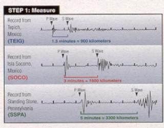
Step 1. The time between the arrival of the P wave and the arrival of the S wave (S-P time) is measured at each station. The S-P time indicates the distance to the earthquake similar to how the time interval between the flash of light and the sound of thunder indicates the distance to a thunderstorm. In our example, station TEIG 9 (with an S-P time of 1.5 minutes) is closest to the earthquake, and station SSPA (with an S-Ptime of 5 minutes) is farthest away.
From observing and analyzing many earthquakes, we know the realtionship between the S-P time and the distance between the station and the earthquake (that's equivalent to know the P- and S-waves speeds). We can therefore convert each measured S-P time to distance. A time interval of 1.4 minutes corresponds to a distance of 900 km., 3 minutes to 1800 km., and 5 minutes to 3300 km. |
|
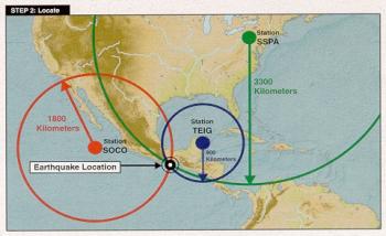
| Step 2. Once we know the distance to the earthquake for three stations, we can determine the location of the earthquake. For each station we draw a circle around the station with a radius equal to its distance from the earthquake. The earthquake occurred at the point where all three circles intersect. |
In practice, the whole process of locating an earthquake is carried out by computer. The computer estimates the arrival time of the P and S waves for each seismic station, the estimates are checked by a seismologist, and then the location is calculated.
Related links |