

|
| |
|
A quick glance on the globus immeditately tells us that most of the Earth surface is covered by water; in fact approximately 2/3 is oceanic and 1/3 is land masses. Another striking feature is the similarities between the coast lines of western Europe and Africa versus the eastern coastlines of North and South America. Likewise, why are earthquakes mainly confined to prolonged, narrow belts along the coastal areas of South and North America? Another example is the thick coal beds in the artic island of Spitsbergen with fossils of plants and creatures which today are only found in the warm trophics. To answer questions of the above kind in any rational manner would intuitively require that the Earth's surface in the past must have been vastly different from that of today and also located at other places. To move continents on the globus does not seem easy since we are restricted by the laws of physics. In other words, the earth apperars firm and solid so such deformations should not be feasible. Geoscientists pondered and discussed the basic problem of a solid, undeformable Earth for many years and indeed agreed that not only do continents move but also forwarded a hypothesis on how such movements take place in accordance with physical laws. Today this is termed The Theory of Plate Tectonics and would be briefly outlined below. In geologic terms, a plate is a large, rigid slab of solid rock. The theory of plate tectonics states that the Earth's outermost layer, the lithosphere, which includes the Earth's crust and the upper part of the mantle, (100-200 km thick) is fragmented into a dozen or more large and small plates that are moving relative to another as they ride atop hotter, more mobile material, the asthenosphere, the part of the mantel right underneath the lithosphere (ca. 200 km thick).The edges of these plates, where they move against each other, are sites of intense geologic activity, such as eartquakes, volcanoes, and mountain building. |
Plate tectonics is a relatively new scientific concept, introduced some 30 years ago. However, some people had already believed that the present-day continents were the fragmented pieces of a preexisting larger landmass: the 'supercontinent' Pangaea. This notion was first suggested as early as 1595 by Abraham Ortelius, who wrote that the Americas were 'torn away from Europe and Africa... by earthquakes and floods' and went on to say: 'The vestiges of the rupture reveal themselves, if someone brings forward a map of the world and considers carefully the coasts of the tree continents'. In 1912 the idea of moving continents was seriously considered as a full-blown scientific theory - called Continental Drift. According to this theory, the supercontinent Pangaea began to break up about 225-200 million years ago, eventually fragmenting into the continents as we know them today. |
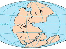
Break-up of the supercontinent Pangaea, 225 million years ago |
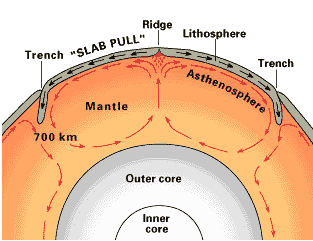
Convection cells in the mantle. Bellow a depth of about 700 km, the descending slab begins to soften and flow, loosing its form. |
But which are the adequate mechanisms for moving the continents like that? For a couple of years most geologists could not believe this new revolutionary theory because of the lack of an answer. Nowadays we think that the forces that move the plates come from the convection currents in the upper mantel.Due to the heat trapped in the Earth interior, there are areas where fluids beneath the crust rise, flow laterally, and then fall. The currents would rise beneath continents, spread laterally, then plunge beneath the oceans. |
|
The Continental Drift Hypothesis had a great revival thanks to the advances in our knowledge of the sea floor and in the magnetic properties of the rocks. It was shown that a ridge exists in the middle of the Atlantic Ocean, and that it is also an active seismic belt. You can easily see this ridge and other ones in the map below, where the oceanic surface of the Earth has been ploted. Thus it was proposed that new ocean floor is formed at the rift of mid-ocean ridges. The ocean floor, and the rock beneath it, are produced by magma that rises from deeper levels, and the ocean floor moves laterally away from the ridge and plunge into an oceanic trench along the continental margin. This hipothesis could be proved by making magnetic tests, taking profit of the earth's magnetic polarity reversal. |
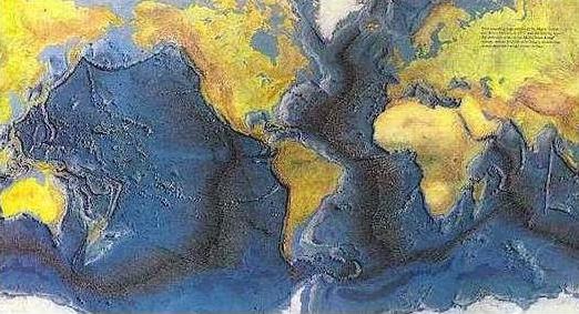
World Ocean floor, by Bruce C. Heezen and Marie Tharp. |
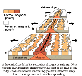
A theoretical model of the formation of magnetic striping. New oceanic crust forming continuously at the crest of the mid-ocean ridge cools and becomes increasingly older as it moves away from the ridge crest with seafloor spreading. |
But if new oceanic lithosphere is created at mid-oceanic ridges, where does it go? The answer to this question was found when having a look to the location of earthquakes. During the 20th century, improvements in seismic instrumentation and greater use of seismographs worldwide enabled scientists to learn that earthquakes tend to be concentrated in certain areas, most notably along the oceanic trenches and spreading ridges. In 1935 a Japanese seismologist showed that earthquakes occured at greater depths towards the interior of the Asian continent. Earthquakes beneath the Pacific Ocean occurred at shallow depths, while earthquakes beneath Siberia and China occurred at greater depths. The explanation to all this was as follows. |
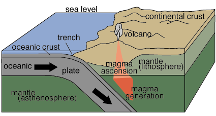
Earthquakes are generated in the rigid plate asit is subducted into the mantle |
|
Convection cells in the mantle help carry the lithosphere away from the ridge. The lithosphere arrives at the edge of a continent, where it is subducted or sinks into the asthenosphere. Thus, oceanic lithosphere is created at mid-oceans ridges and consumed at subduction zones, areas where the lithosphere sinks into the asthenosphere. Earthquakes are generated in the rigid plate as it is subducted into the mantle. The dip of the plate under the continent accounts for the distribution of the earthquakes. Magma generated along the top of the sinking slab rises to the surface to form stratovolcanoes. This model, called Plate Tectonic Theory, has been successfully tested by numerous methods, and is accepted by almost all geologists. The following maps show the location of the different plates. See how their borders correspond to the location of earthquakes and volcanoes. |
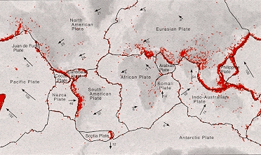 |
Location of magnintude 4 or larger earthquakes and edges of the large plates that make up Earth's crust. The arrows on the map indicate how fast the plates are moving in millimeters per year - about as fast as your fingernails grow. The earthquakes were recorded over a five year time period. |