|
Marine gravitymeter, S-99
Land gravitymeter, G-936 Data format, conversion Air/Sea operation Base readings Data processing Projects Other information June 07, 2024, at 11:36 AM |
BASE READING REPORTJune - September 2008This report covers base readings performed in the period from 29 June 2008 to 30 August 2008. 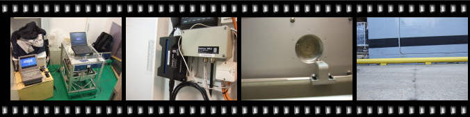 Click to see photo album of all pictures
GRAVITY METER
SURVEYSIMR = Institute of Marine Research
During the summer field season of 2008, Dept. of Earth Science had four marine surveys where the gravity meter was used, on two different vessels. Gravity ties were performed on three occations - one in Tromsø (combining several port of calls for two different vessels), and two in Longyearbyen. The first section of the report details each port of call, providing information on exact location and estimated height difference between marine gravity meter sensor and assumed position of land gravity meter used during gravity ties. The second part describes each gravity tie.
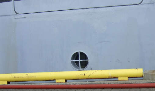
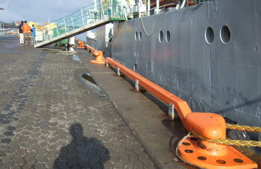
PORT OF CALLSSurvey no. 1, start: "G.O. Sars", 29 June 2008, Tromsø, Rica PierUnfortunately, it was not possible to log gravity data at 10 seconds interval on external computer and merge these data with time and position information. This means that merging of gravity and navigational data must be a separate pre-processing task. The ship's computer system logs time and position at regular intervals, here are these data: Note that time is GPS. During the survey period, GPS is ahead of UTC by ... seconds. 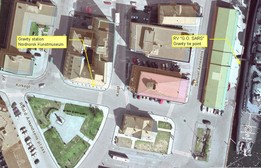 Gravity tie point Tromsø harbour, 29 June 2008
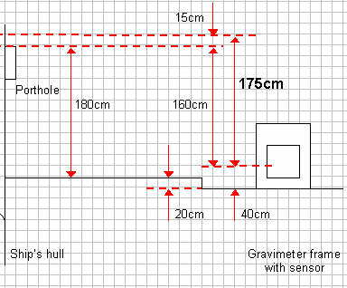
The important dimension in this sketch is the distance from the gravity meter sensor to porthole top: 160 cm. We estimate that land gravitymeter sensor would be 40 cm above top of porthole, which means that: On 29 June 2008, 18:00 UTC, the height between gravity tie point on wharf (assumed land gravity meter posistion) and position of marine gravitymeter sensor was 160+40 = 200 cm. STILL READINGSInspection of raw gravitymeter data reveals that readings are not stable before 18:23 UTC. So if deemed necessary, height should be adjusted. Tide data are available from Tromsø harbour. Get raw gravity data from this file: Choose file:
See hard disk format description (Marine Mode). YYYYDDDHHMMSS GRAVITY SPRING_TENSION CROSS_COUPLING AVG_BEAM ------------------------------------------------------------ 20081811828 0 9773.92 9773.40 .00 9.5 20081811829 0 9773.91 9773.40 .00 10.7 20081811830 0 9773.91 9773.40 .00 11.9 20081811831 0 9773.94 9773.40 .00 13.1
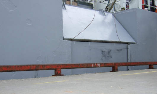
Survey no. 1, finish: "G.O. Sars", 17 July 2008, Tromsø, Breivika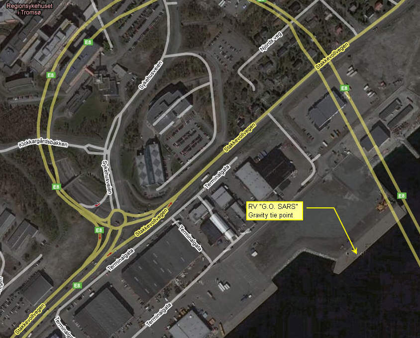 Gravity tie point Tromsø harbour, 17 July 2008 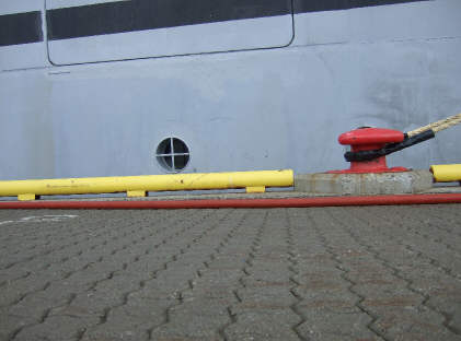 RV "G.O. Sars" 17 July 2008, 12:15 UTC. Photo to determine height difference between tie point and gravity meter. Bollard is 2nd from S. We estimate that land gravitymeter sensor would be 40 cm below top of porthole, which means that: On 17 July 2008, 12:15 UTC, the height between gravity tie point on wharf (assumed land gravity meter position) and position of marine gravitymeter sensor was 160-40 = 120 cm. STILL READINGS: DOY:Time Dig. gravity ST CC Raw TC ------------------------------------------------------------- 199:12:11:10 9775.5 9775.8 0.0 -6.0 -0.3 199:12:12:40 9775.4 9775.8 0.0 -3.0 -0.4 199:12:13:20 9775.4 9775.8 0.0 -5.0 -0.5 where DOY = Day of year. Still readings, screen photo some minutes later: 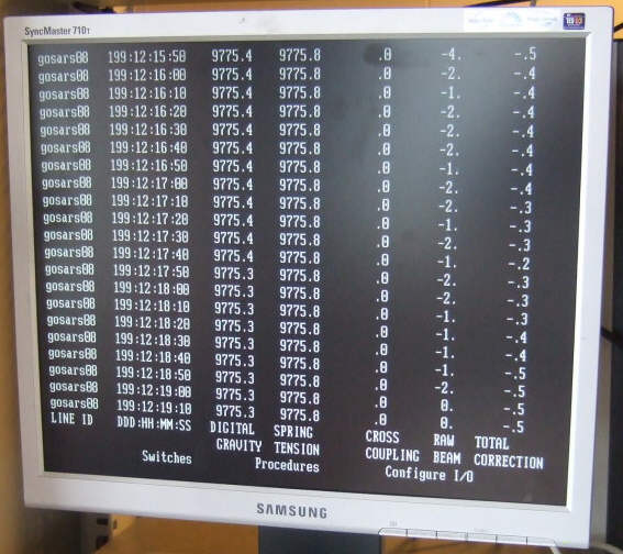 Still readings, G.O.Sars, 17 July 2008
Survey no. 2, start: "Håkon Mosby" 24 July 2008, Tromsø
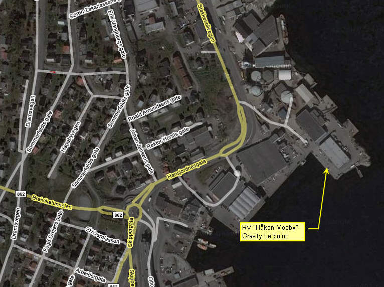 RV "Håkon Mosby" gravity tie point Tromsø harbour (same position used in all visits to Tromsø)''
24 July 2008, 15:10 UTC: Height from gravitymeter sensor to upper deck is 5.7 m. Assumed land gravitymeter position 1.8 m below, so height between marine gravitymeter sensor and land gravitymeter should be 5.7-1.8 = 3.9 m.
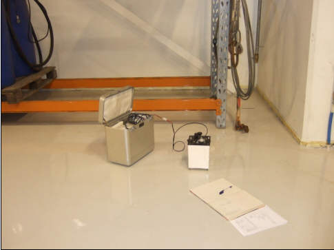
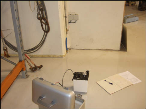
Survey no. 2, finish: "Håkon Mosby" 6 August 2008, TromsøAs part of comprehensive gravity tie procedure, the position near IMR pier depot was measured three times with land gravity meter: 08:10 UTC Tromsø, IMR pier depot, 6 August 2008, 08:10 UTC Tromsø, IMR pier depot, 6 August 2008, 08:10 UTC: Position of land gravitymeter estimated 0.5 m below upper deck, which is 5.7 m above marine gravity sensor. So land gravity meter is 5.7-0.5 = 5.2 m above marine gravity sensor. 09:12 UTC Tromsø, IMR pier depot, 6 August 2008, 09:12 UTC Tromsø, IMR pier depot, 6 August 2008, 09:12 UTC: Position of land gravitymeter estimated 0.1 m below upper deck, which is 5.7 m above marine gravity sensor. So land gravity meter is 5.7-0.1 = 5.6 m above marine gravity sensor. 10:00 UTC Tromsø, IMR pier depot, 6 August 2008, 10:00 UTC Tromsø, IMR pier depot, 6 August 2008, 10:00 UTC: Position of land gravitymeter estimated 0.2 m below upper deck, which is 5.7 m above marine gravity sensor. So land gravity meter is 5.7-0.2 = 5.5 m above marine gravity sensor.
Survey no. 3, finish: "Håkon Mosby" 14 August 2008, Longyearbyen
Longyearbyen, Bykaia, 14 August 2008, 08:05 UTC: Height between gravity meter sensor and top deck is 5.7 m. From this we estimate height from sensor to assumed position of land gravity meter to: 5.7-1.4 = 4.3 m (ref. picture above).
Survey no. 4, start: "Håkon Mosby" 19 August 2008, Longyearbyen Bykaia, 19 August 2008, 13:35 UTC Bykaia, 19 August 2008, 13:35 UTC: Estimated distance between upper deck and assumed land gravimeter position is 2.0 m. Upper deck is 5.7 m above marine gravity sensor, so distance between marine gravity sensor and land gravitymeter is 5.7-2.0 = 3.7 m.
Survey no. 4, part 1: "Håkon Mosby" 22 August 2008, Longyearbyen, Kullkaia
22 August 2008, 13:57 UTC, Longyearbyen, Kullkaia: Estimated distance between upper deck and assumed land gravitymeter position: 1.4 m. Height difference between marine gravitymeter sensor and upper deck is 5.7 m, so distance between marine gravitymeter and assumed land gravitymeter is 5.7-1.4 = 4.3 m. Note: Refer to earlier base readings to obtain the gravity difference between Longyearbyen airport reference site, and Kullkaia:
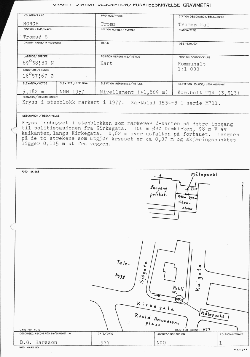
GRAVITY TIESCalibration table, land gravity meterCalibration table, land gravity meter S/N G-936 (click to enlarge) 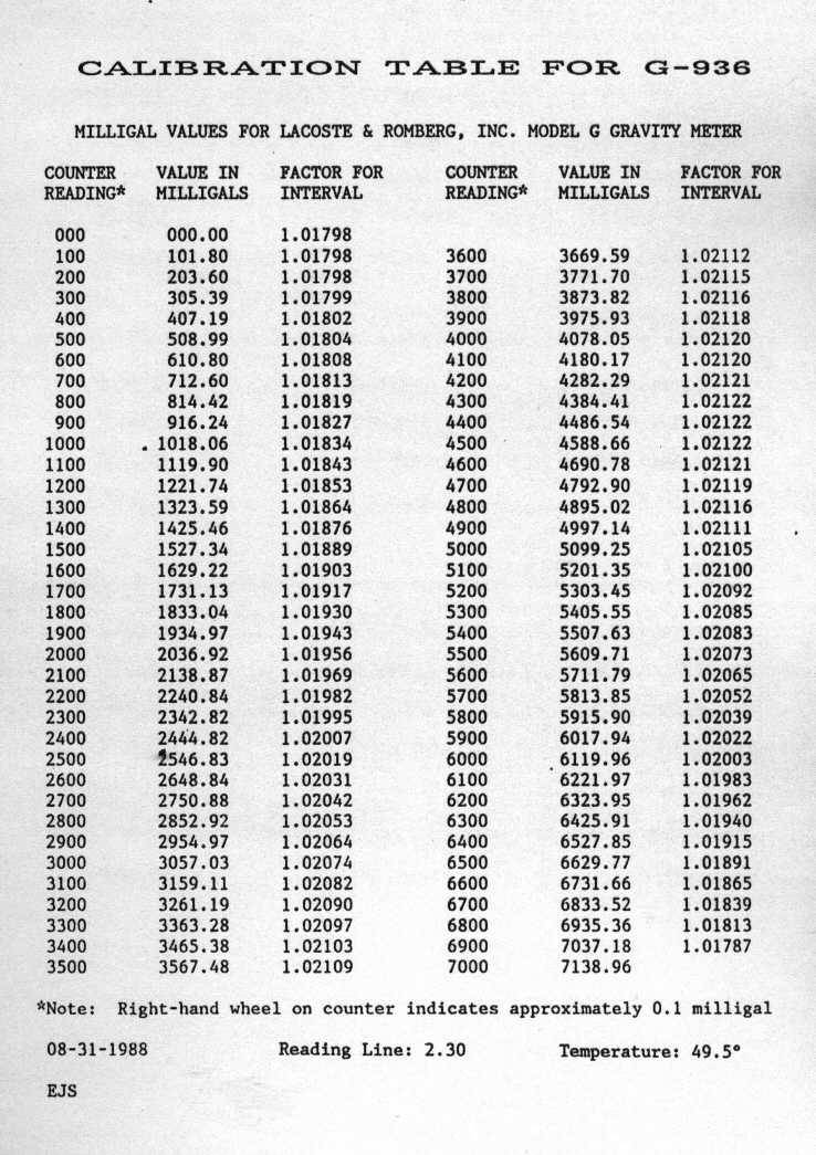 Calibration table, land gravity meter S/N G-936 (click to enlarge) Tromsø gravity reference
Note: There is a small discrepancy in the gravity values given in these documents - 0.07 mgal - for unknown reasons.
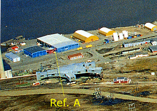
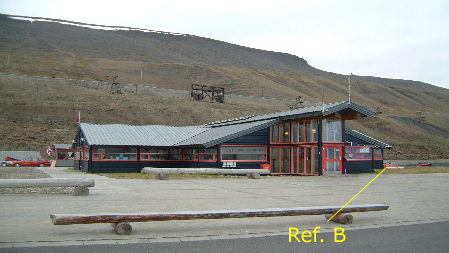
 Tromsø S-point reference Longyearbyen gravity reference - officialUnfortunately the Longyearbyen P reference point has been altered when new terminal was built in 2007. Measurements were made some meters to the east of original point. 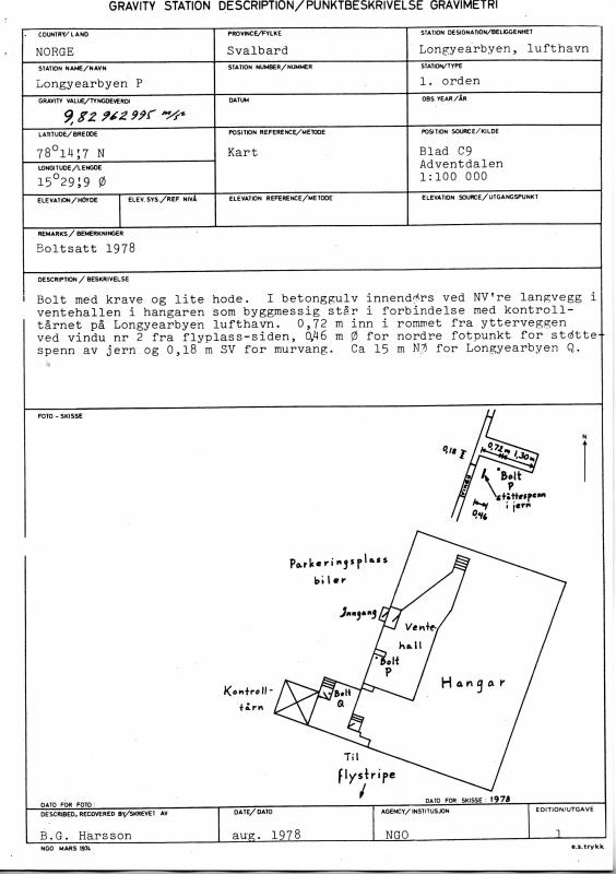  Longyearbyen P-point reference now within hanger area
Longyearbyen gravity references - home brewedBy repeatedly measuring the difference between Longyearbyen official reference point, and two other points near the harbour area, we are trying to establish two new reference points. Previous measurements: Nor-Cargo quay
Main quay ("Bykaia")
6 August 2008, TromsøDate: 6 August 2008 Land gravitymeter used: LaCoste & Romberg, Mod. G, S/N G-936 Location Time [UTC] Counter reading --------------------------------------------------------- IMR pier depot 08:09 6016,10 -"- 08:10 6016,095 -"- 08:12 6016,10 Tromsø ref. point S 08:36 6015.75 -"- 08:38 6015.73 -"- 08:39 6015.74 Rica pier, 7th bollard from S 08:47 6015.57 -"- 08:48 6015.56 -"- 08:50 6015.56 Tromsø ref. point S 08:56 6015.74 -"- 08:58 6015.75 -"- 08:59 6015.74 IMR pier depot 09:10 6016,11 -"- 09:11 6016,14 -"- 09:12 6016,11 Breivika, 3rd bollard from S 09:26 6018.94 -"- 09:27 6018.92 -"- 09:28 6018.91 Tromsø ref. point S 09:44 6015.74 -"- 09:45 6015.74 -"- 09:46 6015.735 IMR pier depot 09:55 6016,10 -"- 09:57 6016,11 -"- 09:58 6016,105 15 August 2008, Longyearbyen
Date: 15 August 2008
Land gravitymeter used: LaCoste & Romberg, Mod. G, S/N G-936

Location                    Time [UTC]    Counter reading
---------------------------------------------------------
Longyearbyen ref.point P       09:49         6418.205
  -"-                          09:51         6418.204
  -"-                          08:12         6418.205

City quay ("Bykaia")           10:12         6420.35
  -"-                          10:14         6420.35
  -"-                          10:16         6420.35
19 August 2008, Longyearbyen
Date: 19 August 2008
Land gravitymeter used: LaCoste & Romberg, Mod. G, S/N G-936

Location                    Time [UTC]    Counter reading
---------------------------------------------------------
Nor-Cargo quay                 09:46         6421.63
  -"-                          09:51         6421.63
  -"-                          09:52         6421.63

City quay ("Bykaia")           10:05         6421.13
  -"-                          10:12         6421.13
  -"-                          10:13         6421.13

Longyearbyen ref.point P       10:33         6419.01
  -"-                          10:35         6419.01
  -"-                          10:36         6419.01

City quay ("Bykaia")           10:50         6421.15
  -"-                          10:52         6421.15
  -"-                          10:53         6421.15

Nor-Cargo quay                 13:15         6421.63
  -"-                          13:16         6421.63
  -"-                          13:17         6421.63
26 August 2008, LongyearbyenDifference between City quay ("Bykaia") "reference point" and ship's position at this quay.
Date: 26 August 2008
Land gravitymeter used: LaCoste & Romberg, Mod. G, S/N G-936

Location                    Time [UTC]    Counter reading
---------------------------------------------------------
Ship's position                19:30         6420.690
  -"-                          19:31         6420.690

City quay ("Bykaia")           19:39         6421.095
  -"-                          19:41         6421.095
|