|
Surveys and data Instruments
Support to other department sections Support Dr. Scient. thesis Contribution to "Scientific infrastructure"
Obsolete, kept for reference
Last update: April 30, 2025, at 08:49 AM |
INTRODUCTIONAn OBS survey will be conducted in the Barents Sea region in the period 28 July - 14 August 2012. Both Ocean Bottom Seismographs and land based sensors will be deployed. The source consists of marine airguns. The research vessel RV "Håkon Mosby" will be used.
DATAProfiles
GRAVITY METERBase reading TROMSØ 27 July 2012 a) Nord-Norsk Kunstmuseum:
UTC COUNTS
---------------
15:27 6017.32
15:29 6017.44
15:31 6017.83
b) Tromsø Bunkersdepot, alongside ship:
Height, water level to quay: 2.8 meter
UTC COUNTS
---------------
15:51 6020,47
15:53 6020,75
15:55 6021,16
c) Still reading (also check raw gravity meter files, when they are available).
NOTE: Ref gravity meter log book: Still readings made earlier that day are not valid as meter was still unclamped.
-----------------------------------------------------
DoY UTC DG ST CC RAW TC
-----------------------------------------------------
209 18:00:00 14253.8 14237,7 0.0 246 17.1
(Gravity meter had obviously not reached steady state when these data were taken.
Assume the ship left harbor shortly afterwards.)
Base reading Longyearbyen, "Gamlekaien = NorCargo = Bring", 22 August 2012 a) Still reading:
-----------------------------------------------------
DoY UTC DG ST CC RAW TC
-----------------------------------------------------
235 16:40:00 14654.0 14653.8 0.0 16.0 0.1
b) Entry, Governor's Office: ("Syssselmannen, inngang")
UTC COUNTS
---------------
17:00 6422.24
17:02 6422.26
17:05 6422.23
c) Quay, "Gamlekaien = NorCargo = Bring":
h = 2.88 m
UTC COUNTS
----------------
17:10 6421.29
17:14 6421.25
17:16 6421.29
d) Still reading:
-----------------------------------------------------
DoY UTC DG ST CC RAW TC
-----------------------------------------------------
235 17:20:00 14654.0 14653.8 0.0 35.0 0.2
235 17:45:00 14654.1 14653.8 0.0 -5.0 -0.3
Base reading Longyearbyen, "Gamlekaien = NorCargo = Bring", 30 August 2012 (SVALEX-2012) a) Still reading:
-----------------------------------------------------
DoY UTC DG ST CC RAW TC
-----------------------------------------------------
243 08:55:00 14651.6 14652.0 0.0 8.0 0.0
b) Entry, Governor's Office: ("Syssselmannen, inngang")
UTC COUNTS
---------------
09:07 6422.14
09:10 6422.16
09:12 6422.16
c) Quay, "Gamlekaien = NorCargo = Bring":
h = 3.05 m
UTC COUNTS
----------------
09:17 6421.07
09:21 6421.03
09:25 6421.07
d) Still reading:
-----------------------------------------------------
DoY UTC DG ST CC RAW TC
-----------------------------------------------------
243 09:30:00 14651.6 14651.6 0.0 18.0 0.3
243 12:00:00 14651.6 14651.6 0.0 31.0 0.1
HSE - HEALTH, SAFTETY, ENVIRONMENTMaterial Safety Datasheets
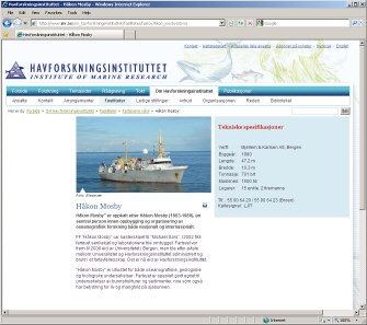
RV "HÅKON MOSBY"Vessel information
GUN CONTROLLER "GUNCO"GUNCO connector wiringThe key to understand the GUNCO connector system is to see how the front slot positions of the MSIBG cards corresponds to the connectors on the rear side - see figure below. We normally only use one MSIBG card located in slot #5. This card will thus have sensors connected on SI3 (labelled "STBD1,2"), and solenoids on SO5 (labelled "STBD 1").  GUNCO connector principle.
GUNCO rack wiring (rear view)Current systemClick to open PDF document: 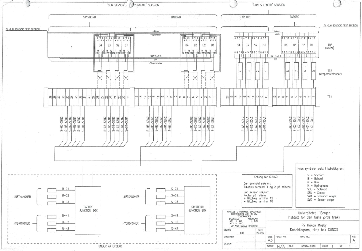 GUNCO Rack cabling. Click to open PDF version. Old systemThe difference is that relays have been added for the airgun solenoid test unit, which allows the operator to monitor sensor voltage and current, and measure resistance to solenoid. 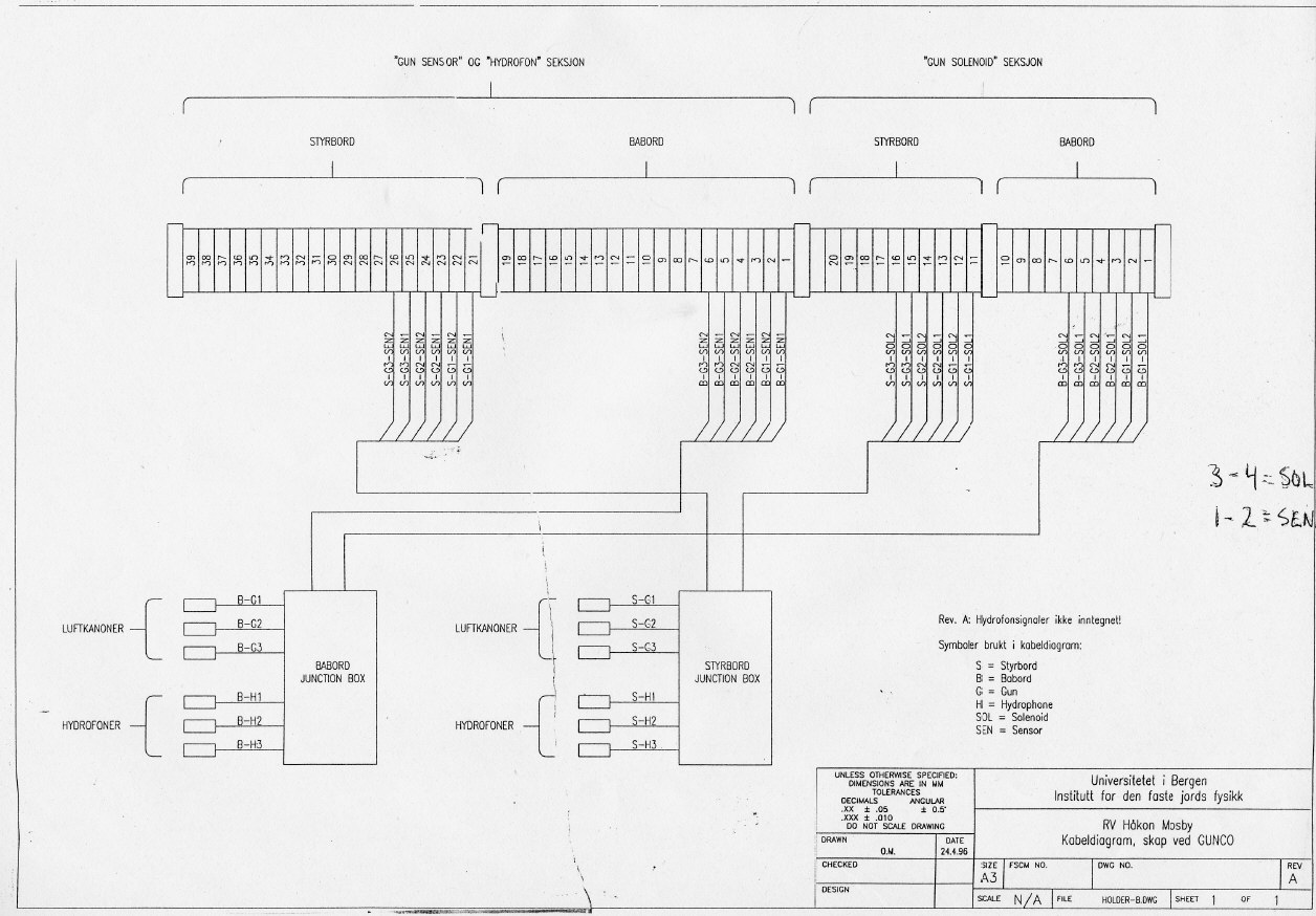
GUNCO Sensor DisplayThis is what a GUNCO sensor display could look like. Click to see larger version. NOTE: Airgun no. 1,2 and 6 is OK. No. 5 has crossfeed from the solenoid pulse; the "crosfree blanking" feature of the GUNCO is activated (red area), causing any signal that appears within the read zones to be ignored.  GUNCO sensor display. Click to enlarge.
MINI-STREAMER RECORDING SYSTEMWe will use a two-channel mini-streamer, and record data on a Geometrics GEODE, which is controlled from a PC laptop running Windows. 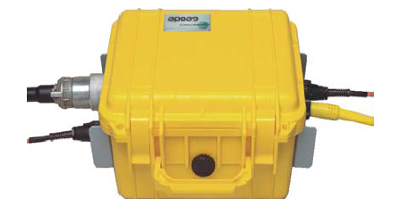
TIME-STAMPING OF GUNCO SHOT EVENTSThe Ocean Bottom Seismographs that are deployed on the sea floor keeps time using very accurate internal clocks. It is necessary to obtain time stamp of every shot event in order to process data later on. The time stamping is done by routing the "SCOPE TIME BREAK" from GUNCO signal to a GPS based event recorder. The "SCOPE TIME BREAK" signal is emitted on "Zero time" - the nominal firing moment of all guns, according to the timing method that has been selected from GUNCO menus. It is emitted in sequence after two control signals have been asserted correctly - the CLOSURE and FIRE signal. The relationship between these three signals is shown below. 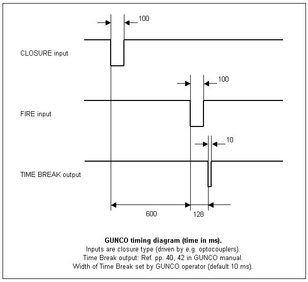 Gun Controller timing diagram. So the falling edge of the SCOPE TIME BREAK signal is used as input for the time stamping unit, which is documented below (click to open documentation web page).  Time stamping unit - click to see information.
GRAVITYMETER Air/Marine Gravitymeter LaCoste & Romberg, S-99 LogsheetsLogshets can be downloaded from this page: http://www.geo.uib.no/eworkshop/gravitymeter/index.php?n=Main.LogSheets Base readingsTromsøRef. this report: http://www.geo.uib.no/eworkshop/gravitymeter/index.php?n=Main.Reports-2008-OBS-SVALEX LongyearbyenMore later ....
RECORDING LOG SHEET
LOGISTICS, DEPLOYMENT OF LAND STATIONSCargo handlingTschudi Northern Logistics AS The Tschudi group has offices in Kirkenes and also Denmark (Virum), see contact web page link below. Tschudi Northern Logistics AS Sydvaranger Industriområde N-9900 Kirkenes Postal address: PO Box 405 N-9915 Kirkenes Telephone: +47 92 69 99 92 E-mail: agencykirkenes(at)tschudilogistics.com Accommodation - Kirkenes
Car rental Kirkenes
LAND STATIONSIntroductionThe initial plan is to deploy seismic sensors according to the following arrangement:
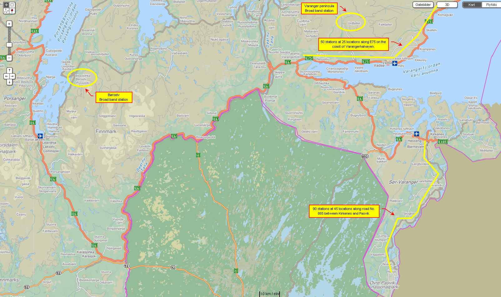
Click to see large view of approximate land station locations: To deploy a seismic broad band station temporarily it could be useful to contact the following institutions:
Municipalities in FinnmarkHere is an overview of municipalities in Finnmark 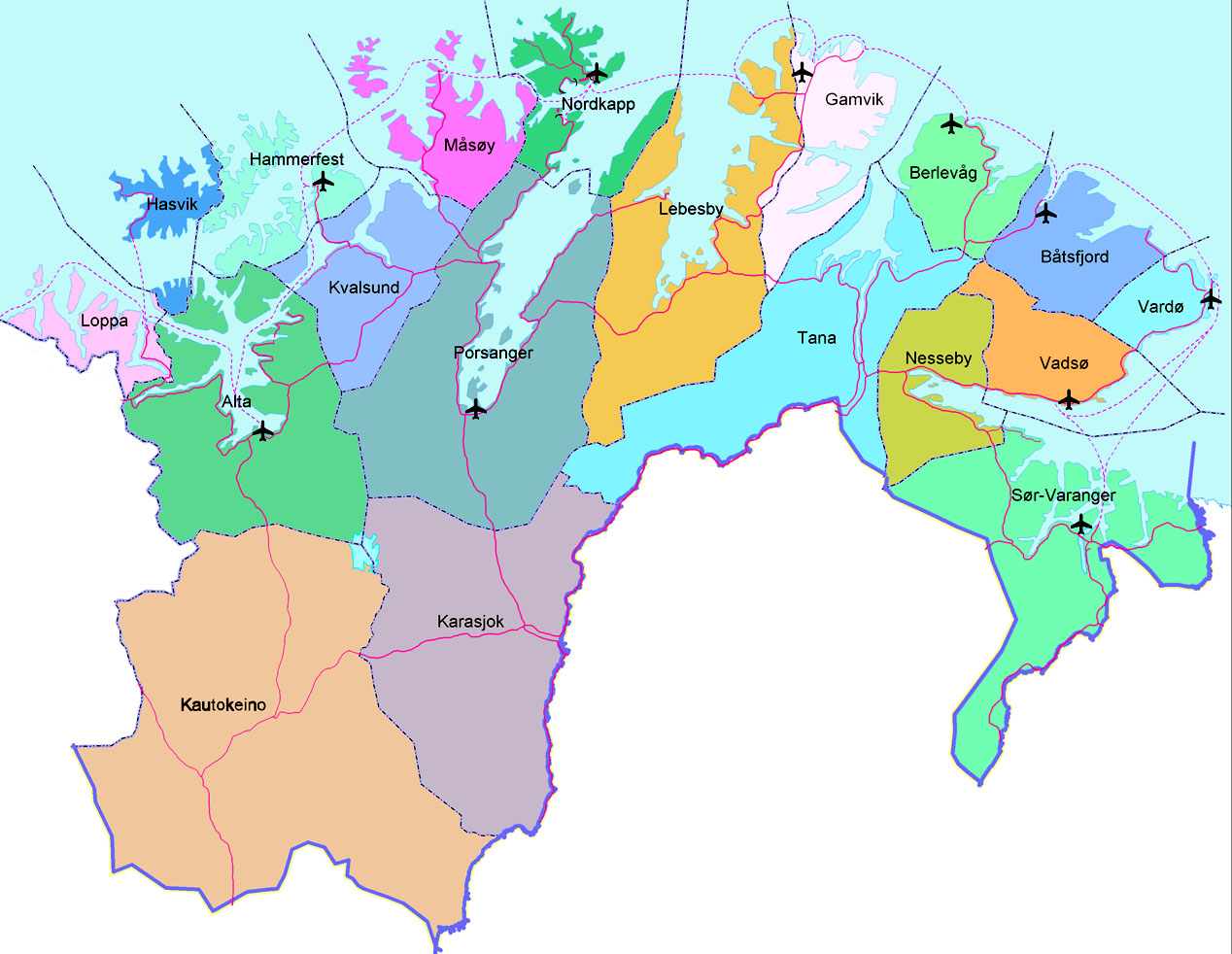 Municipalities in Finnmark Direct link to all municipalities in Finnmark: Power generating / distributing companies in FinnmarkNorwegian Public Roads Administration, Øst-Finnmarkemail: firmapost-nord@vegvesen.no Web page: http://www.vegvesen.no/en/Home
|
|||||||||||||||||||||||||||||||||||||||||||||||||||||||||||