|
Marine gravitymeter, S-99
Land gravitymeter, G-936 Data format, conversion Air/Sea operation Base readings Data processing Projects Other information June 07, 2024, at 11:36 AM |
HEIGHT DATUMSEARTH GRAVITATIONAL MODELSThe development and evaluation of the Earth Gravitational Model 2008 (EGM2008), by Nikolaos K. Pavlis, Simon A. Holmes, Steve C. Kenyon and John K. Factor A comparison of recent Earth gravitational models with emphasis on their contribution in refining the gravity and geoid at continental or regional scale, by D. N. Arabelos · C. C. Tscherning
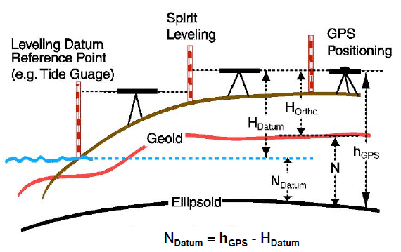
HEIGHT DATUMS USED IN NORWAY
Statens Kartverk standards
http://kartverket.no/Kart/Nautiske-hjelpemidler/Tidevann-og-vannstand/ NN2000NN2000 is based on "Normaal Amsterdams Peil", which is also reference for the new European height datum EVRF2007. European Vertical Reference System (EVRS)
GEIOD UNDULATION VALUES WITH RESPECT TO WGS84The height difference between the geoid and WGS84 ellipsoid - what's called the geoid undulation values with respect to WGS84 - for a certain lat/lon location can be calculated. To my knowledge, Earth Gravitational Model EGM2008 is the latest "official" geoid model and software for computing undulation values are here: http://earth-info.nga.mil/GandG/wgs84/gravitymod/egm2008/egm08_wgs84.html On-line calculators are also available, e.g. this one at UNAVCO, but is uses EGM1996 so might be of limited value now:
OCEAN TOPOGRAPHY.") The mean dynamic topography of the world oceans (in metres). Source: ESA. Data collected by the GOCE = Gravity Field and steady-state Ocean Circulation Explorer mission. http://en.wikipedia.org/wiki/Ocean_surface_topography http://en.wikipedia.org/wiki/TOPEX/Poseidon
SATELLITE GRAVITY MEASUREMENTSESA: GEOCE - Gravity Field and steady-state Ocean Circulation ExplorerGOCE = Gravity Field and steady-state Ocean Circulation Explorer mission. Analyse der Gradiometergleichungen der GOCE Satellitenmission zur Schwerefeldbestimmung, Diplomarbeit C. Stummer, Institut für Astronomische und Physikalische Geodäsie, Technische Universität München (an exquisite piece of work). Quote from ESA GOCE web page. By the middle of 2014, no less than five gravity field models and corresponding geoids had been generated from GOCE's data. Each version more accurate than the last. The fifth gravity model and geoid, includes all of the gravity data collected throughout the lifetime of the mission – right up until November 2013 when the satellite finally stopped working and succumbed to the force it was designed to measure.
Electrostatic Gravity Gradiometer
GPS receiverThales Alenia Space's plant in Milan, Italy produced the sophisticated GPS receiver that enabled determining the satellite's orbit to within a centimeter, thus ensuring high-precision measurements of the gravitational field.
GRACE - Gravity Recovery and Climate ExperimentThe Gravity Recovery And Climate Experiment (GRACE), a joint mission of NASA and the German Aerospace Center, has been making detailed measurements of Earth's gravity field anomalies since its launch in March 2002.
GRACE mission GRACE, on ESA site GRACE, on GFZ Potsdam site GRACE Related Publications (no abstracts, sorted by date) GRACE Follow-On Mission, from Univ. of Texas GRACE Follow-On, Albert Einstein Institute Hannover |
|||||||||||

 or Amsterdam Ordnance Datum. Click to enlarge.")