FRAM-2014/14: a Norwegian ice drift 118 years after the FRAM
Vision
To contribute to exploration of the Arctic Ocean paleoenvironment of the Late Cretaceous “greenhouse world” and
document a possible asteroid impact by:
Carrying out an intensive data acquisition effort to provide research opportunities for the best relevant expertise within
the scientific community
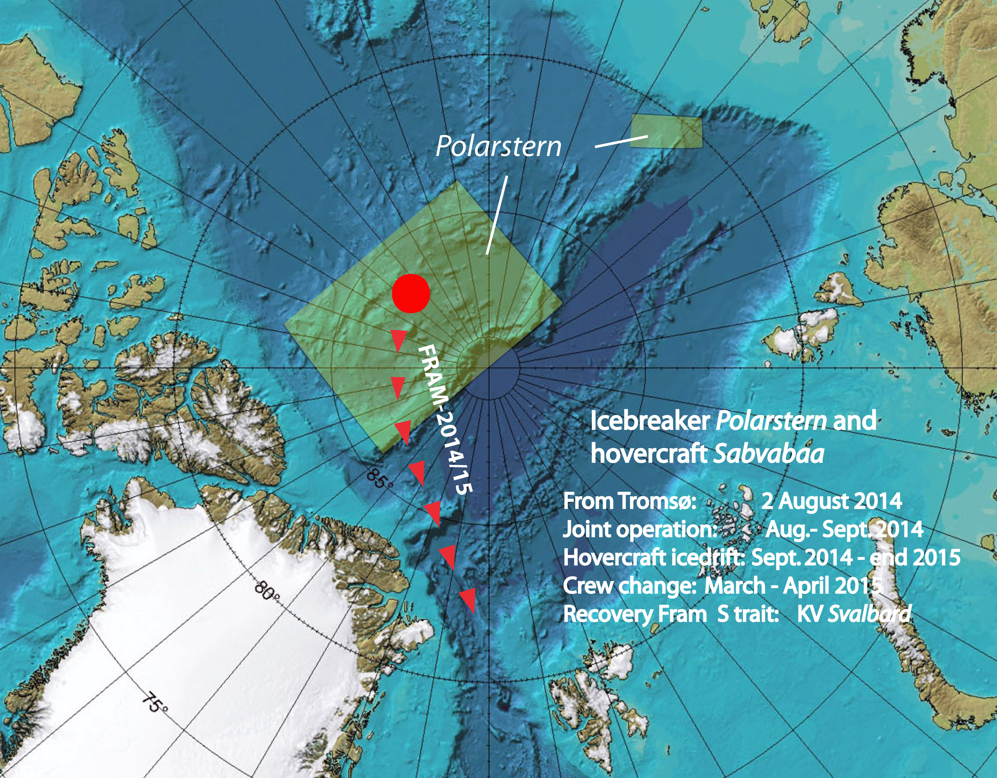 Outline of the general expedition plan.
Background
After over 50 years of geological exploration of the Arctic Ocean, about one thousand short sediment cores have been recovered from
the sea bed – all representing sediments deposited over the last few million years. Four of them however, contain sediments 50-75
million years old and document an Arctic Ocean with high, but variable algal blooms, a stratified water mass and bottom waters low in
oxygen. These cores were recovered from a 600 km x 200 km area where the sea bed is severely disturbed and massive submarine slides
have taken place (Kristoffersen et al., 2008). Here, older sediments are exposed on steep slopes and readily accessible with
conventional geological sampling tools. The area is north of Canada where the multi-year ice is thickest and no icebreaker has ventured
into so far. Ice drift stations are still the only alternative platform in the Arctic Ocean in areas not generally accessible to
icebreakers and also to support year around observations of the water column, ice and the atmosphere. The main difference between
traditional ice drift stations and a hovercraft in ice drift mode is mobility which translates to safety. With the hovercraft, you
have a permanent set-up for accommodation and communication and can relocate yourbase within a few minutes if an undesirable ice
situation develops.
Outline of the expedition plan
The A. Wegener Institute of Polar and Marine Research (AWI) is carrying out a cruise with icebreaker POLARSTERN with focus on sampling
Mesozoic sediments in the central Arctic Ocean. In a cooperative venture between AWI and the Nansen Environmental and Remote Sensing
Centre (NERSC), the icebreaker will carry the hovercraft SABVABAA into the work area (Fig. 1). The hovercraft will operate as a work boat
for the icebreaker and after about 5 weeks, the icebreaker leaves the hovercraft behind with supplies to operate on its own for the next
18 months. This is necessary because all seabed surveys have to be done in ice drift mode and sufficient time is essential. Also frequent
low visibility during the late fall limits hovercraft driving.
Resupply and crew change will be by aircraft out of Resolute, Canada in March-April 2015. The ice drift towards the Fram Strait is
expected to last at least until the end of 2015 and the intent is to recover the craft and equipment by the Norwegian Coast Guard vessel
SVALBARD south of 84 N. The Norwegian FRAM-2014/15 ice drift station represents a new generation ice drift stations which has mobility
and can operate out to 100 km from the base station.
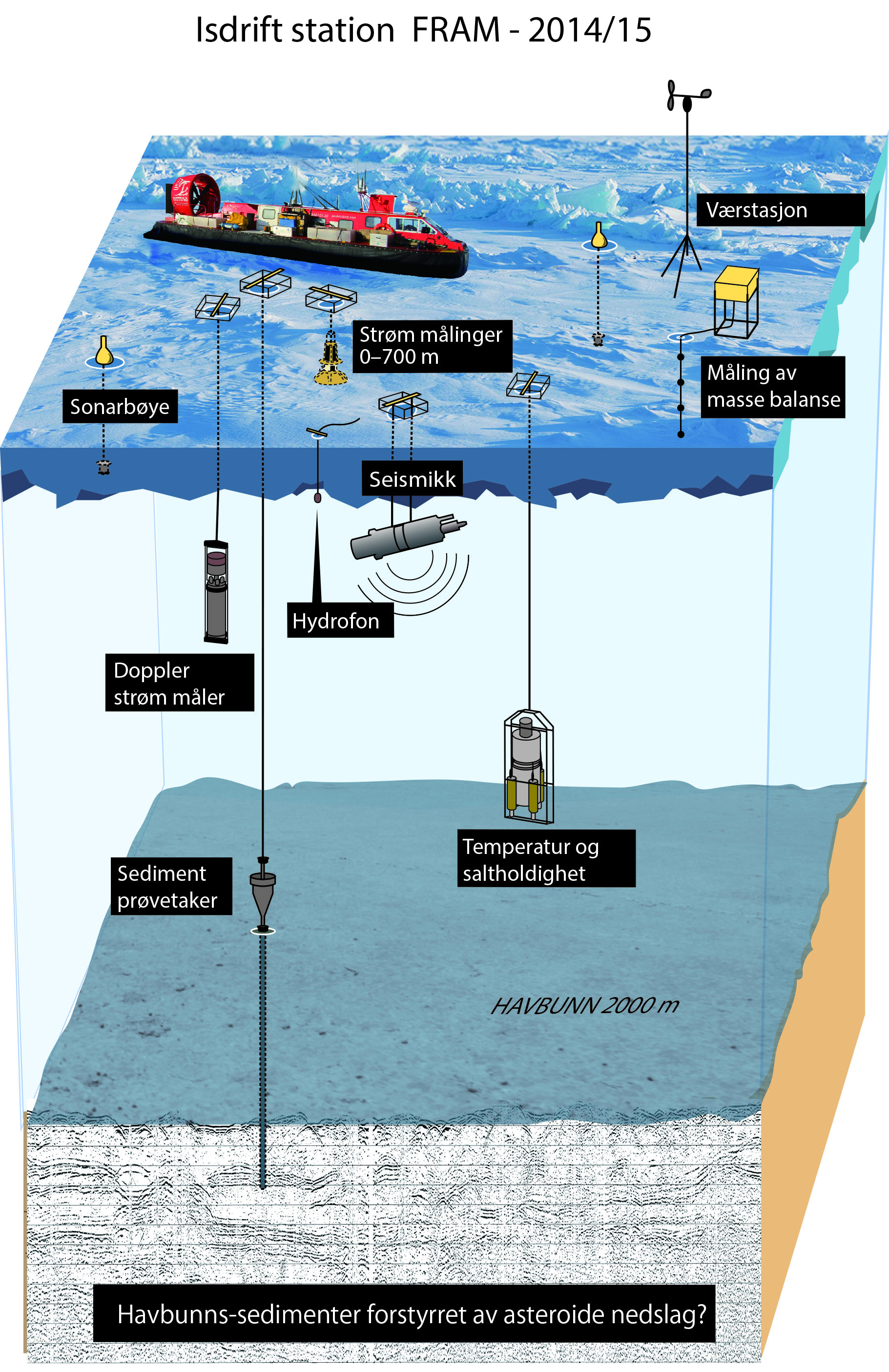 Overview of scientific activities at the FRAM-2014/15 ice drift station.
The ice drift station
The hovercraft SABVABAA is manned by a crew of two; professor Yngve Kristoffersen , NERSC/University of Bergen and Audun Tholfsen,
Longyearbyen. Supplies and equipment deployed from POLARSTERN will be moved to the nearest floe of thick multi-year ice and a base
established. The thick floe should be at least 300 meters across. Here a “hangar” of 3 m high and 0.5 m thick walls of ice and snow will
be built to house the hovercraft. The hangar will be covered with a tarp and include a laboratory area with a 1 m x 1 m hole in the
ice for geological sampling. Fuel is stored in pillow tanks on the ice enclosed by 0.5 m thick ice walls. Oceanographic , ice and
meterological instruments will be deployed in the vicinity of the hangar.
The scientific measurement program
- Geology/geophysics:
- Geological sampling of older sediment outcropping on slopes
- Sediment coring for upper sediments (Multi-corer)
- Seismic reflection measurements with3.5 kHz Chirp echo sounder and 0.3 liter air gun.
Signals recorded by camp hydrophone & 4 continuously recording sonobuoys
- Five autonomous buoys for echo sounding spaced at 10 km interval and reporting via Iridium
- One autonomous seismic sparker buoy reporting via Iridium
- Heat flow measurements
- Towed camera sled for bottom photography
- Oceanography:
- Automatic Doppler Current Measurements 0- 700 m depth
- Aanderaa current meters suspended at 3 levels in the water column
- Termistorstring 0-300 m depth
- Probe for ocean microstructure and turbulence measurements
- CTD measurements to bottom at regular intervals.
- 200 kHz echo sounder for monitoring of scattering layers
- Ice:
- Thermistorstring in the ice
- EM- ice thickness and snow observations repeated over a 100 sq.km grid at regular intervals
- Ice deformation grid monitored by GPS trackers
- Meterology:
- Measurement of incoming and outgoing long and short wave radiation
- Automatic weather station
Safety
The hovercraft SABVABAA is equipped with all required emergency equipment and as well as additional
items considered useful for our particular operation. This includes:
- Emergency beacon (deck mounted)
- Float for 6 persons
- Emergency suits for 2 persons
- Life vests
- Emergency box on deck containing:
Tent, down sleeping bags (2), sleeping mat (2), cooking equipment,
food for 2 for one week, Emergency beacon, Iridium telephone, GPS, spare batteries.
- Rifle
- Emergency flares
- Motion detector for polar bear alert
- 24 ea LED lights for runway marking during the dark season
Communication
All communication is via Iridium satellites.
- Iridium Pilot telephone for voice (1), for data (1), spare phones (2).
- Satellite tracker with automatic reporting to web-page every hour.
four spare trackers for marking of fuel depot or instruments
- VHF for aircraft communication
- VHF for maritime communication
A binding Search And Rescue agreement between polar coastal states is in effect from 2011 and the ice drift
has been communicated with the US Air Force- and US Coast Guard Joint Rescue Centres in Anchorage and Juneau, Alaska,
respectively. Representative authorities in Canada, Greenland and Norway have been notified.
Institutions involved
The Nansen Environmental and Remote Sensing Centre is responsible for the FRAM-2014/15 expedition. The cooperation
with A. Wegener Institute, Helmholtz Centre for Polar and Marine Research is laid down in a joint Memorandum of Understanding
between the two institutions.
The FRAM-2014/15 expedition is supported by contributions from Lundin Norway AS, Blodgett-Hall Polar Presence LLC and
the Bjerknes Centre for Climate Research. Contributions from other sources are pending.