
|
Surveys and data Instruments
Support to other department sections Support Dr. Scient. thesis Contribution to "Scientific infrastructure"
Obsolete, kept for reference
Last update: April 30, 2025, at 08:49 AM |
INTRODUCTIONClean-up of http://www.geo.uib.no/eworkshop/OBS-2003/gravitymeter-basereadings/
DATA FORMAT DIFFERENCE BETWEEN HIGH-RESOLUTION AND MARINE MODEReferring to the UltraSys format description dated June 14, 1999: ultrasys-data-formats.html Gravity data on this survey was logged in high-resolution mode - normally, marine mode should be used. Be aware of the gravity data format difference between high-resolution and marine mode. The hard disk data has the same structure in both these cases: EXAMPLE: IIIIIIIIIIYYYYDDDHHMMSSGGGGG.GGSSSSS.SSCCCC.CCBBBBBB.BVVVVVVV. LLLLLLL.XXXXXXX.#######.-------------etc---------#######.HHHHHHHH PPPPP.AAA.AAA---etc----AAA.AAA. The important detail is the gravity value (GGGGG.GG) which in marine mode is given in mGal or counter units, as selected by the operator. In high-resolution mode, the gravity value is always given in counter units, updated at 10 sec intervals. But the "Video Gravity Display" will give gravity in mGal units - independant of mode setting.
GRAVITY REFERENCE POINT, REALFAGBYGGET
Lat/Long, WGS84 datum Realfagbygget gravity reference station, 60.38440º N, 5.32948º E (60° 23′ 3.8″N, 5° 19′ 46.1″E). Datum = WGS84. Map source: http://kart.finn.no/ Click to enlarge. Height - MASL Map source: http://www.bergenskart.no/bergen/ Select "Turkart". Click to enlarge.  Map source: http://kart.finn.no/ Click to enlarge. In the Realfagbygget gravity station description, height is stated to be 20.8 meter, with reference datum "NN54" which means "Norsk null av 1954" - a Norwegian national reference established in 1954. (The Norwegian mean sea level reference is updated at regular intervals, feed this news article into Google translate: "From 1 January 2015, 37 cm is added to Oslo mean sea level"). If this value is uncertain we can contact Bergen municipality, mapping office and get information about reference points they have in the vicinity. Using a laser leveling surveying tool is should be fairly easy to determine the height of the gravity reference point. GPS determination of height valueThis is an idea for determining the height of the gravity reference point in Realfagbygget, measured in the GPS system. There are details in the relationship between "Mean Sea Level", Geiod and the WGS84 ellipsoid that need careful consideration, as outlined in this ESRI article.
BASE READING 20 MAY 2003, DOKKEN, BERGEN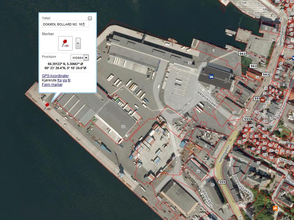 Dokken, position of land gravity meter. 60.39122º N, 5.30667º E (60° 23′ 28.4″N, 5° 18′ 24.0″E) Datum = WGS84. Map source: http://kart.finn.no/ 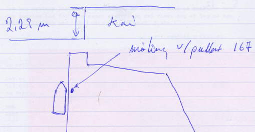 Fig 1. May 20, 2003, base reading Dokken, Bergen: Location NOTE: This base reading is divided into two parts:
Still reading marine gravity meterFrom video display: Day:HH:MM Gravity Spring tension Cross coupling Raw beam Total correction
[mGal] [Counter units] [Counter units] [mV] [Counter units]
------------------------------------------------------------------------------------------------------
140:20:06 11968.4 11968.5 0.0 4.0 0.1
140:20:15 11967.5 11967.0 0.0 4.0 0.6
140:20:34 11967.2 11967.0 0.0 -1.0 0.0
Tying Dokken to Gravity station in Realfagsbygget, Bergen
Using land gravity meter: Location Reading Time (local) ----------------------------------------------------------------------- Realfagbygget, Bergen 5392,125 13:22 -- " -- 5392,215 13:34 -- " -- 5392,180 13:40 Dokkeskjærskaien, bollard no. 167 (labelled no. 10 on side that faces the sea) 5395,941 14:16 -- " -- 5395,912 14:20 -- " -- 5395,979 14:23 -- " -- 5395,950 14:25 Realfagbygget 5392,108 14:54 -- " -- 5392,205 14:57 -- " -- 5392,190 14:59
BASE READING 30 JUNE, 2003, MARINEHOLMEN, BERGEN,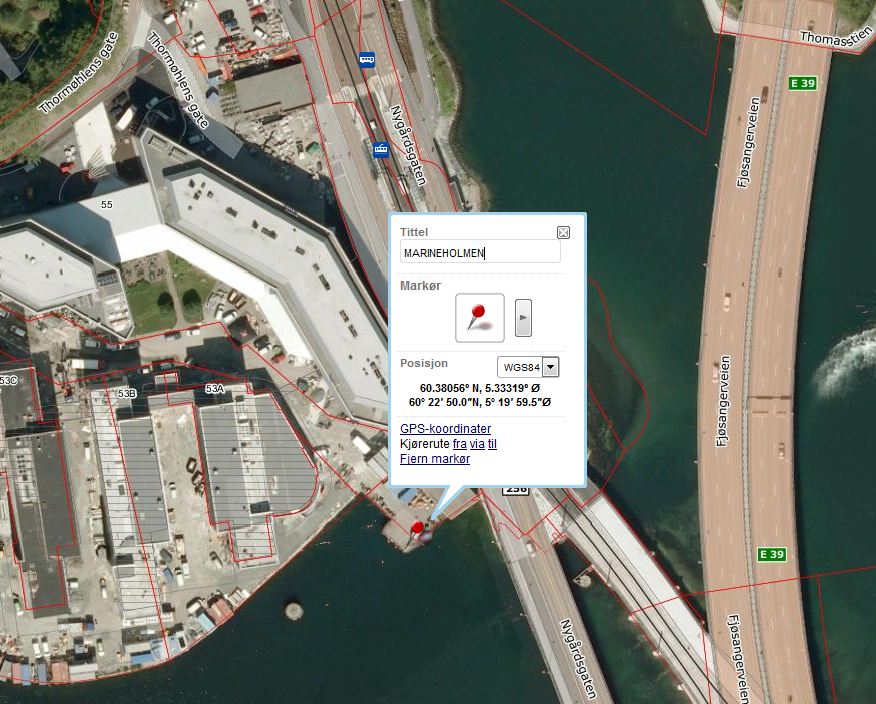 Marineholmen, position of land gravity meter: 60.38056º N, 5.33319º E (60° 22′ 50.0″N, 5° 19′ 59.5″E). Datum = WGS84. Map source: http://kart.finn.no/ 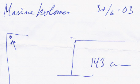 Fig 2. June 30, 2003, base reading Marineholmen, Bergen: Location NOTE: This base reading also is divided into two parts:
Still reading marine gravity meterFrom video display: Day:HH:MM Gravity Spring tension Cross coupling Raw beam Total correction
[mGal] [Counter units] [Counter units] [mV] [Counter units]
------------------------------------------------------------------------------------------------------
181:08:41 11956.6 11956.3 0.0 6.0 0.4
181:09:05 11956.6 11956.3 0.0 2.0 0.3
181:09:25 11956.5 11956.3 0.0 -2.0 0.1
Tying Marineholmen to Gravity station in Realfagsbygget, Bergen
Using land gravity meter: Location Reading Time (local) ----------------------------------------------------------------------- Realfagbygget, Bergen 5392,360 11:01 -- " -- 5392,310 -- " -- 5392,323 Marineholmen, close to bollard shown in fig. 2 5394,380 11:24 -- " -- 5394,380 -- " -- 5394,395 Realfagbygget 5392,320 11.55 -- " -- 5392,275 -- " -- 5392,338
L&R LAND GRAVITY METER, G-MODEL, S/N: G-936 LaCoste & Romberg Model G (for Geodetic) gravity meter. Click to enlarge. Calibration table Calibration table land gravimeter L&R S/N: G-936. Click to enlarge. Converting the counter reading to milliGalsExcerpt from p.1-9 of G-936 Instruction Manual is given below.
  If the counter reading is 2654.32, look at the calibration table for your meter. Remember that each meter has its own unique table.

                          Portion of calibration table
     _____________________________________________________________________________
    /                                                                             \
   /    Counter reading           Interval factor           Cumulative value       \

            2500   ..............     1.00794    .............   2519.42
    +---->  2600   ..............     1.00799    .............   2620.21  <---+
    |       2700   ..............     1.00805    .............   2721.01      |
    |       2800   ..............     1.00811    .............   2821.82      |
    |                                                                         |
    |    Divide the reading into two parts:                                   |
    |                                                                         |
    +---->  2600.00                               2620.21  <------------------+
            + 54.32                                +54.75  <----+
            -------                               -------       |
            2654.32                               2674.96       |
                                                                |
         Interval factor x reading within interval              |
                                                                |
                               1.00799 x 54.32 = 54.75  <-------+
Here is link to newer version of the Model-G manual where the conversion example is on page 1-9. If readings are within a separate interval in the calibration table, instructions are provided on page 1-10: More information of relevance: |
|||||||||

