SVALEX-2010
 SVALEX-2010 on RV "Håkon Mosby": Click to see photo album.
INTRODUCTION
SVALEX is an annual student field course that takes place on Svalbard. It is a cooperative effort between several universities in Norway, and sponsored by Statoil.
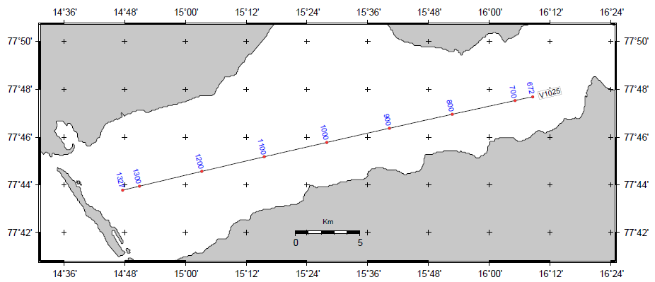
The course activities covers a broad range of topics and are located at different sites. Department of Earth Science is responsible for the marine seismic survey, using research vessel "Håkon Mosby". Data is acquired by a 3 km, 240 ch digital streamer and also processed on board, using SeismicUnix.
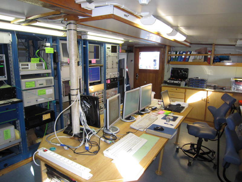
Few students have visited a seismic vessel, so at first sight the instrumentation can appear overwhelming. After a while, however, the task of each sub-system - "birds" (i.e. vertical streamer control), airgun control system, streamer recording and navigation - becomes clear and the students will quickly be able to monitor the complete seismic acquisition process unaided. As a safety precaution, instructors employ an automatic web based system running in the background, providing continuous supervision of important parameters (distance off line, airgun pressure and timing, streamer bird positioning) with alarm settings on each.
 RV "Håkon Mosby" instrumentation lab.
HSE - HEALTH, SAFTETY, ENVIRONMENT
Material Safety Datasheets
| Description
| Document
|
| HSE datasheet ISOPAR-M - oil used in all sections of main streamer
| Link
|
| HSE datasheet MOBILECT-44 - oil used in mini-streamer
| Link
|
Lithium batteries for Streamer Birds, HSE datasheet.
Battery supplier: http://www.iongeo.com/
| Link
|
Airgun handling
| Applies to
| Procedure
|
| Single airgun: Deployment
|
- One person from the crew of HÅKON MOSBY is needed to handle the crane, as well as at least one trained person from GEO; a maximum of 3 persons. Before commencing the deployment of the guns, one must make sure that the trigging is switched off (GUNCO is in SAFE position), and that the gun is not filled with air under pressure. Remember to inform the bridge.
- The gun is deployed to ca. one meter above the sea surface. At this point the gun has to be filled with air, and lowered to the required depth.
- This procedure is repeated until all single guns are in the sea. When the deployment is finished, the responsible in the instrument room and the bridge must be informed.
|
| Single airgun: Recovery
|
- One person from the crew of HÅKON MOSBY is needed to handle the crane, as well as at least one trained person from GEO; a maximum of 3 persons. Before recovery, one must make sure that trigging is switched off (GUNCO is in SAFE position), and that the compressor is switched off. The bridge must be informed.
- Before the recovery of the gun, the air-supply must be switched off, and the air-pressure must be decreased to ca. 20 kg. The gun is recovered to ca. one meter above the sea surface. At this point the air must be removed from the gun.
- The gun is recovered on board the ship. IMPORTANT: WHEN THE GUN IS TO BE LOWERED ONTO THE DECK, THE GUN MUST NEVER BE TOUCHED; USE THE ATTACHED ROPE. When the gun is on board, recover the harness. Inform the bridge and the instrument-room when the guns are on deck.
Concerning use of personal safety-equipment, it is referred to the internal safety instructions for marine seismic fieldwork (enclosed).
|
Streamer handling
During deployment and recovery of the streamer the following procedure must be followed:
- One person (from the ship crew) is needed to maneuver the crane, and two persons, with the proper training, is needed from GEO. Max. 4 persons. Before starting deployment/recovery; notify the bridge.
- During deployment and recovery the stern port must be open. Therefore all persons who work near the rear end of the deck must wear survival suit and line, or life west and line, in addition to ordinary safety outfit, As soon as the stern port has been opened and the tail buoy has been deployed, a rope should be attached across the stern port.
- During deployment/recovery birds must be attached/detached to the streamer. A high level of precaution must be held by the person who is lifting the birds across the stern port. If refilling of fluid (ISOPAR-M) in the streamer is needed, spilling on deck must be avoided, since oil on deck causes this to become very slippery. When the streamer has been completely deployed, the cable reel must be secured with its brake. When the deployment/recovery has been completed, the responsible in the instrument laboratory and the bridge must be notified.
- As long as the streamer is in the sea the stern port will remain open. Personal movements on the rear deck should be limited to a minimum. Persons who need to go there should always notify the instrument laboratory/bridge beforehand.
As for use of personal safety equipment/outfit, it is referred to "Internal safety instructions for marine seismic fieldwork".
RECORDING LOG SHEET
SEISMIC SURVEY PARAMETERS
Most of this information also placed in UKOOA P1/90 headers.
Source
- 4 airguns, total volume: 766 CUIN
- No 1: BOLT 1900 90 CUIN
- No 2: BOLT 1500 240 CUIN
- No 3: BOLT 1500 300 CUIN
- No 4: BOLT 1900 136 CUIN
- Depth nominal: 6 M
- Pressure nominal: 138 BAR
- Distance nav reference location to source: 36 meter
Streamer
- Distance nav reference location to first seismic channel: 136 meter
- It follows that OFFSET SHIP SYSTEM 1ST CH: 100.0 M
Navigation
- Nav reference location = Position of gravity meter
- Nav data UTM Zone: 33X
NAVIGATION / GRAVITY / MAGNETOMETER DATA
These data sets were collected by the so-called EIVA Survey Computer (a normal PC running EIVA NaviPac software).
| LINE
| START OF LINE
SP Date Time
Easting Northing (UTM Zone 33X)
| END OF LINE
SP Date Time
Easting Northing (UTM Zone 33X)
| EVENT FILE
file
| 10 s
FILE
| AUTO-LOG
|
| Svalex10-21
| 000017 2010.08.24 12:37:09.018
0496396.01 08626455.75
| 000661 2010.08.24 16:19:09.220
0527732.22 08633863.93
| Link
| Link
| Link
|
| Svalex10-22
| 000008 2010.08.25 06:49:45.436
0495067.54 08626641.73
| 000662 2010.08.25 10:33:10.318
0526886.68 08634180.21
| Link
| Link
| Link
|
| Svalex10-23
| 000052 2010.08.26 08:51:28.697
0497384.54 08627707.28
| 000659 2010.08.26 12:22:57.073
0526917.30 08634702.57
| Link
| Link
| Link
|
| Svalex10-25
| 000672 2010.08.24 16:40:09.557
0526934.18 08635717.83
| 001327 2010.08.24 20:30:23.324
0495061.77 08628186.76
| Link
| Link
| Link
|
| Svalex10-27
| 000670 2010.08.25 11:00:06.823
0524761.28 08636215.78
| 001294 2010.08.25 14:32:46.981
0494388.07 08629080.45
| Link
| Link
| Link
|
| Svalex10-34
| 001124 2010.08.26 17:01:57.538
0495145.20 08632830.19
| 001604 2010.08.26 19:53:40.186
0518504.15 08638340.35
| Link
| Link
| Link
|
| Svalex10-35
| 000666 2010.08.26 13:45:29.483
0517416.58 08638594.14
| 001111 2010.08.26 16:18:54.423
0495766.04 08633465.00
| Link
| Link
| Link
|
| Svalex10-36
| 001614 2010.08.27 06:48:01.887
0501777.28 08635420.01
| 001916 2010.08.27 08:31:14.831
0516480.50 08638857.57
| Link
| Link
| Link
|
| SvalexIN-17
| 002629 2010.08.29 11:07:31.856
0494701.30 08723974.58
| 003125 2010.08.29 13:57:37.420
0505239.17 08701524.79
| Link
| Link
| Link
|
| SvalexIN-18b
| 003835 2010.08.30 12:35:16.810
0495368.43 08723779.49
| 004573 2010.08.30 16:49:45.587
0511008.82 08690358.14
| Link
| Link
| Link
|
| SvalexIN-19
| 001904 2010.08.29 06:58:11.191
0510877.56 08692119.09
| 002621 2010.08.29 10:56:45.655
0495533.93 08724519.63
| Link
| Link
| Link
|
| SvalexIN-20b
| 003134 2010.08.30 08:36:41.002
0511049.66 08693301.18
| 003826 2010.08.30 12:24:21.943
0496099.44 08724506.06
| Link
| Link
| Link
|
| SvalexIN-21
| 001238 2010.08.28 17:02:00.041
0511622.70 08692622.77
| 001898 2010.08.28 20:55:51.694
0497588.91 08722489.96
| Link
| Link
| Link
|
| SvalexIN-23
| 000615 2010.08.28 13:08:04.436
0499538.98 08720776.01
| 001229 2010.08.28 16:48:32.666
0512544.19 08692966.81
| Link
| Link
| Link
|
| SvalexIN-25
| 000005 2010.08.28 09:31:57.894
0513217.54 08694301.68
| 000608 2010.08.28 12:56:58.837
0500245.64 08721518.86
| Link
| Link
| Link
|
- TRIACQ recording log files - directory listing. Files with suffix ".label" contain tape storage summary.
NOTE:
There is a discrepancy between Eiva SP log file numbering, and numbering of Triacq "*.label" files.
Eiva SP log numbering assumed to be correct.
UKOOA P1-90 NAVDATA, SHOT POINT MAPS
 Click to open shot point map directory, or select file from table below.
- The UKOOA P1/90 navigation data format is described in this document.
- The QC plot files contains the following parameter fields. They enable quality control of the SP offset adjustment calculations.
SP, oldEasting, oldNorthing, oldLat, oldLon, newEasting, newNorthing, newLat, newLon
- Shot point maps are provided as PDF files (open directory listing). Take screenshots from PDF viewer and convert to JPG or other image format, as needed. Remember to open the PDF file separately in Adobe Acrobat Reader, which provide a clear rendering of fonts and lines (unlike some PDF viewers that are browser embedded).
SOFTWARE TO PRODUCE UKOOA P1/90 FILES
Software to produce UKOOA P1/90 navdata files comprises two parts:
- A general part, independent of any specific profile parameters
- A part that is specific for each area
Part that is specific for each area:
General part
Generate WIKI table of UKOOA/QC files
GRAVITY METER
A L&R (modified by ZLS) air/sea gravity meter was used during the entire survey. As our own is deployed elsewhere, we used the danish S-38.
Base reading 22 August 2010
- Location: Nor-Cargo pier, Longyearbyen
- All times in UTC
  a) Marine gravity meter

     -----------------------------------------------------------------------------------------------------
     DOY:HH:MM:SS     Digital gravity    Spring tension    Cross coupling    Raw beam     Total correction
     -----------------------------------------------------------------------------------------------------
     234:15:42:30         10184.1            10184.0            0.0             12             0.5
     234:15:43:30         10184.2            10184.0            0.0              9             0.6

     Distance land gravity meter to sea surface: 3.8 m

  b) Alongside vessel

     Time [UTC]    Counts
     ----------------------
       15:55       6418.893
       15:57       6418.890
       16:00       6418.895

  c) "Reference" Nor-Cargo

     Time [UTC]    Counts
     ----------------------
       16:11       6420.015
       16:13       6420.015
       16:14       6420.015


  d) Alongside vessel

     Time [UTC]    Counts
     ----------------------
       16:24       6418.905
       16:26       6418.903
       16:27       6418.905


  e) Marine gravity meter

     -----------------------------------------------------------------------------------------------------
     DOY:HH:MM:SS     Digital gravity    Spring tension    Cross coupling    Raw beam     Total correction
     -----------------------------------------------------------------------------------------------------
     234:16:29:10         10184.4            10184.4            0.0             -9            -0.2
     234:16:30:30         10184.3            10184.4            0.0            -10             0.6
  f)  6420.0 - 6418.9 = 1.1 count difference between pier/"reference" reading land gravitymeter.
      10184.4 + 1.1 = 10185.5 Digital gravity, with reference to Nor-Cargo rep. point.
Base reading 31 August 2010
- Location: Kullkaia, Longyearbyen
- All times in UTC
  a) Marine gravity meter

     -----------------------------------------------------------------------------------------------------
     DOY:HH:MM:SS     Digital gravity    Spring tension    Cross coupling    Raw beam     Total correction
     -----------------------------------------------------------------------------------------------------
     243:10:53:20         10182.9            10183.1            0.0             -5             -0.3

     Distance land gravity meter to sea surface: 3.8 m

  b) Alongside vessel

     Time [UTC]    Counts
     ----------------------
       11:11       6420.415
       11:12       6420.420
       11:13       6420.425

  c) "Reference" Nor-Cargo

     Time [UTC]    Counts
     ----------------------
       11:50       6420.00
       11:51       6420.00
       11:52       6420.00

  d) Alongside vessel

     Time [UTC]    Counts
     ----------------------
       12:03       6420.425
       12:04       6420.50
       12:06       6420.43


  e) Marine gravity meter

     -----------------------------------------------------------------------------------------------------
     DOY:HH:MM:SS     Digital gravity    Spring tension    Cross coupling    Raw beam     Total correction
     -----------------------------------------------------------------------------------------------------
     243:12:14:00         10182.9            10183.1            0.0             16            -0.7
  f)  6420.0 - 6420.4 = -0.4 count difference between pier/"reference" reading land gravitymeter.
      10182.9 - 0.4 = 10182.5 Digital gravity, with reference to Nor-Cargo rep. point.
Gravity data

