
|
Surveys and data Instruments
Support to other department sections Support Dr. Scient. thesis Contribution to "Scientific infrastructure"
Obsolete, kept for reference
Last update: April 30, 2025, at 08:49 AM |
The project had participants from these institutions:
The survey was conducted from May 20 to June 30, 2003, using University of Bergen research vessel RV Håkon Mosby. This web page is a revised edition of the original site. DATA, LOG FILES, FORMAT DESCRIPTIONSData and log files
Table 1: Data, log files Note 1): During the survey, GPS time was ahead of UTC time by 13 seconds. The decision to introduce a leap second in UTC is the responsibility of the International Earth Rotation Service (IERS).
Note 2): Data in Seismic Unix format. This is modified SEG-Y, refer to description on this web page: ./Seismic-Unix. Data recorded in little-endian form. To read these files on big-endian machines first use the SUSWAPBYTES command in Seismic Unix, ref.: SUSWAPBYTES info page. Airgun pressure recorded in some files; the SUT trace header field was used for this purpose. The SURANGE command (also part of Seismic Unix) will show if the SUT field is in use.
Format description Survey Computer (EIVA) log filesShot (= Event) files; format example:004105 20:19:49 0711074.16 07809167.80 01.00 160.0 00969.12 -06.23 141.600 Filtered 2490.80 52816.00 12683.04 Field no. Example Parameter Notes --------------------------------------------------------------------------------------------------------------------------------- 1 004105 Shot (event) number 2 20:19:49 Time Survey computer time not accurate - could differ by more then 10 seconds from UTC. 3 0711074.16 UTM Easting Referred to antenna position in mast. 4 07809167.80 UTM Northing Referred to antenna position in mast. 5 01.00 Standard deviation 6 160.0 Gyro compass reading 7 00969.12 DAL = Distance along line [m] 8 -06.23 DOL = Distance off line [m] 9 141.600 KP = Kilometer post 10 Filtered (check) 11 2490.80 Depth From EK500 Echo Sounder 12 52816.00 Magnetometer (Length of mag tow fish cable - check!) 13 12683.04 Gravity meter (check - filtered, raw??) Table 2. Shot (event) file format description. Logging of depth, gravity- and magnetometer data every 10 seconds; format example:06:21:59 23.05.2003; 553674.1175;6744618.7726; 060°49.995410'; 003°59.234563'; 326.2000; 12008.8500; 50667.0000 Field no. Example Parameter Notes
---------------------------------------------------------------------------------------------------------------------------------
1 06:21:59 Time Survey computer time not accurate - could differ by more then 10 seconds from UTC.
2 23.05.2003 Date
3 553674.1175 UTM Easting Referred to position of crane used to deploy the OBS.
4 6744618.7726 UTM Northing Referred to position of crane used to deploy the OBS.
5 060°49.995410' Latitude
6 003°59.234563' Longitude
7 326.2000 Depth From EK500 Echo Sounder
8 12008.8500 Gravity (check - filtered, raw??)
9 50667.0000 Magnetometer (Length of mag tow fish cable - check!)
Table 3. 10 second interval log file format description. Logging of OBS deployment positions, example:Event 00001 Wednesday, June 11, 2003 07:47:27 MANUAL Message: OBS72 Cycle at 0.740 Gyro 320.35 Roll 0.00 Pitch 0.00 Heave 0.00 SOG 0.08 COG 63.78 LOP Code System Measurement Converted Error Wgt -------------------------------------------------------------------------------- 0 1 GPS1 (NMEA): Seapath 558940.057 558940.081 0.152 1.00 1 1 GPS1 (NMEA): Seapath 7640272.663 7640272.614 -7.836 1.00 2 1 GPS2 (NMEA): Trimble 558933.681 558933.768 0.918 1.00 3 1 GPS2 (NMEA): Trimble 7640292.477 7640293.055 2.864 1.00 4 1 Gyro: User Defined g 320.350 318.984 315.637 0.00 Position Easting Northing Height S.td Data --------------------------------------------------------------------------------- 1 : 558940.410 7640277.937 0.00 5.36 Filtered : 558939.738 7640277.812 0.00 -1.00 - Kran : 558937.809 7640273.477 0.00 0.00 - EK500 : 558934.193 7640279.616 -1.00 0.12 D 2995.50 B 1.00 input 1: : 559071.664 7640127.033 0.00 0.72 D 56013.00 B 0.00 input 2: : 558940.410 7640277.937 0.00 0.39 D 12534.17 B 0.00
INSTRUMENTATIONBlock diagram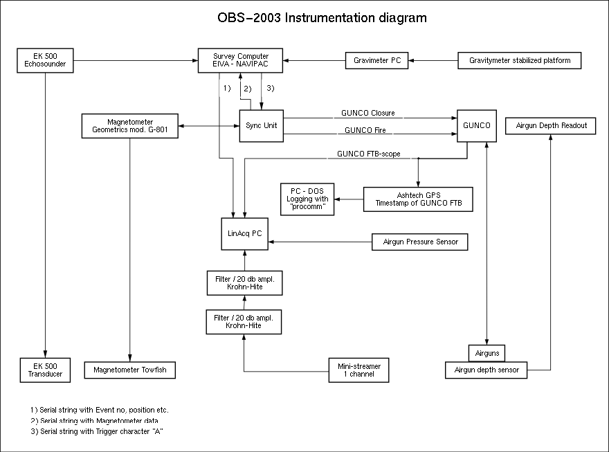 Fig. 1. OBS-2003 Survey Instrumentation block diagram. Airgun source layout, signature, spectrumClick image below to download pdf version. 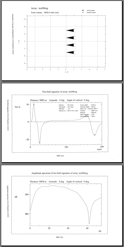 Fig 2: Airgun source layout, signature, spectrum. Click to download pdf version. Software used: NUCLEUS, by PGS.
NOTESASHTECH GPS, used for timestamp of GUNCO FTB.Ashtech GPS had to be reconfigured at start of survey. Use the Ashtech Evaluate program - there are two directories, "evaluate1" that holds unzipped main file, ready to be installed, and "Ashtech Evaluate" that is copied from already installed version (the latter may or may not work if it is just copied to a new PC). Send these commands to the GPS (a modified version of this config file): Command Description ------------------------------------------------------------------------- $PASHS,RST Reset with default settings $PASHS,SYS,MIX Set receiver in mixed GPS/GLONASS mode $PASHS,PEM,5 Set elevation mask to 5 degrees $PASHS,NME,RMC,C,ON Send NMEA message RMC on port C $PASHS,NME,PER,1.0 Set NMEA "send message interval" to 1 Hz $PASHS,PHE,F Set event marker signal to falling edge $PASHS,PPS,01.00,+000.0000,F Set 1PPS trigger edge to falling edge $PASHS,NME,TTT,B,ON Output Event marker message on port B $PASHS,TSC,GPS Output Event marker time in GPS-system-time $PASHS,SAV,Y Save settings in battery backed-up memory If this GPS should fail: Use the GUNSTAMP system (ask Trond S.). TeraTerm terminal program - for setup of OBSThis terminal program permits 600 bits/second datarate, this is not common in other terminal programs. Download from TeraTerm homepage. Status web page with ship position, 24h track line, OBS positions and weather information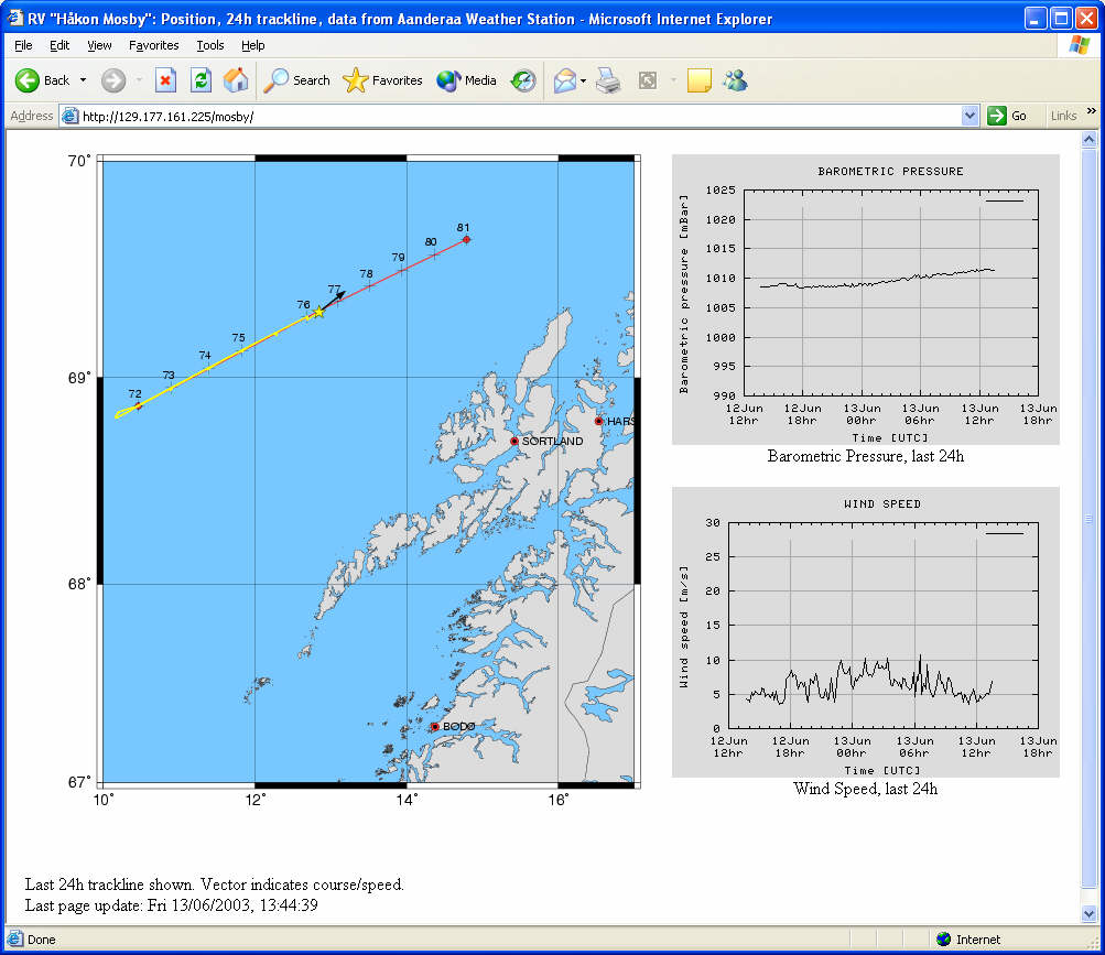 Fig. 2. Web page showing ship's position, 24h track line, OBS positions and data from Aanderaa Weather Station. The map showing ship's position and past 24 hour track line is updated every minute. The weather station graphs are updated every 10 min. The web page itself is refreshed every 30 sec. More information on this software:
|


